Highway 41 Corridor Improvements
 Skip to main content

On Tuesday, August 24, 2021, Charleston County Council voted 9-0 to move the Compromise Alternative forward through the environmental review process and further into design.
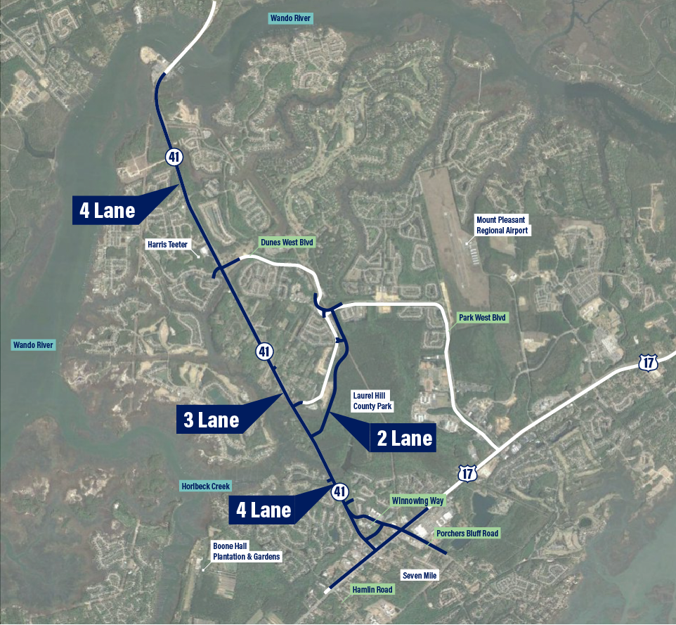
The Compromise Alternative consists of:
Benefits of the Compromise Alternative include:
View a detailed map of the Compromise Alternative.
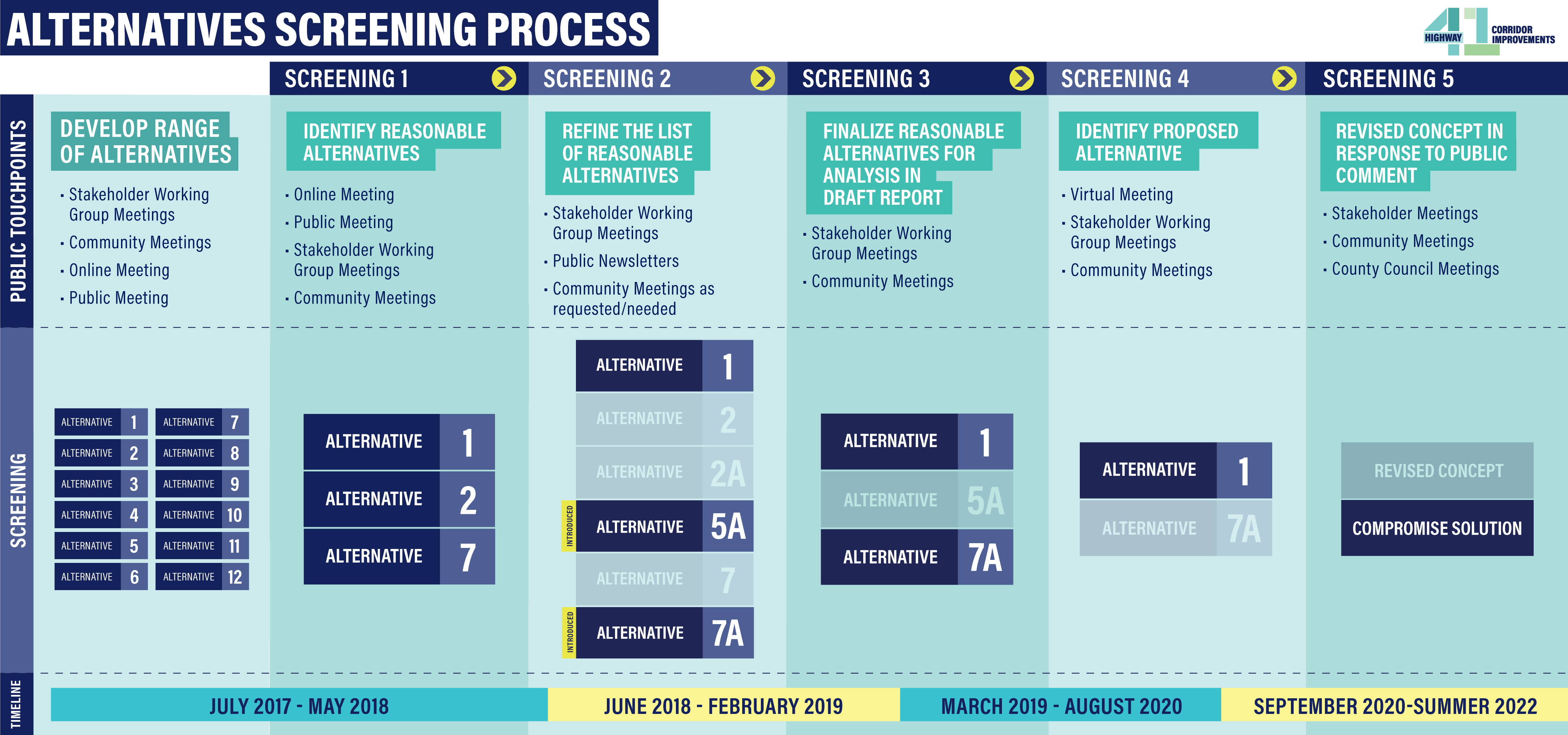
Since the project kicked off in 2017, the Charleston County project team has diligently followed a rigorous environmental review process, which included extensive public involvement and a detailed alternatives evaluation of 15 alternatives to examine environmental, social, cultural, and economic impacts of the proposed project.
The process has worked, and the project team was able to identify a Compromise Alternative that is reflective of the needs of surrounding communities while also managing the growing traffic congestion along Highway 41.
All Alternatives Updates as well as presentations to the public, stakeholders and Council can be found on the Resources page.
The project team is committed to continuing to work closely with surrounding communities and stakeholders as the project design, Environmental Report, U.S. Army Corps of Engineers (USACE) permit application, and the South Carolina Department of Environmental Services (SCDES) permit application are being reviewed.
Updated versions of the Environmental Report and Supporting Documentation may be viewed here, and more information can be found at USACE - SC 41 Corridor Improvements Charleston County, South Carolina.
The project's right-of-way plans were approved by SCDOT in July 2025.
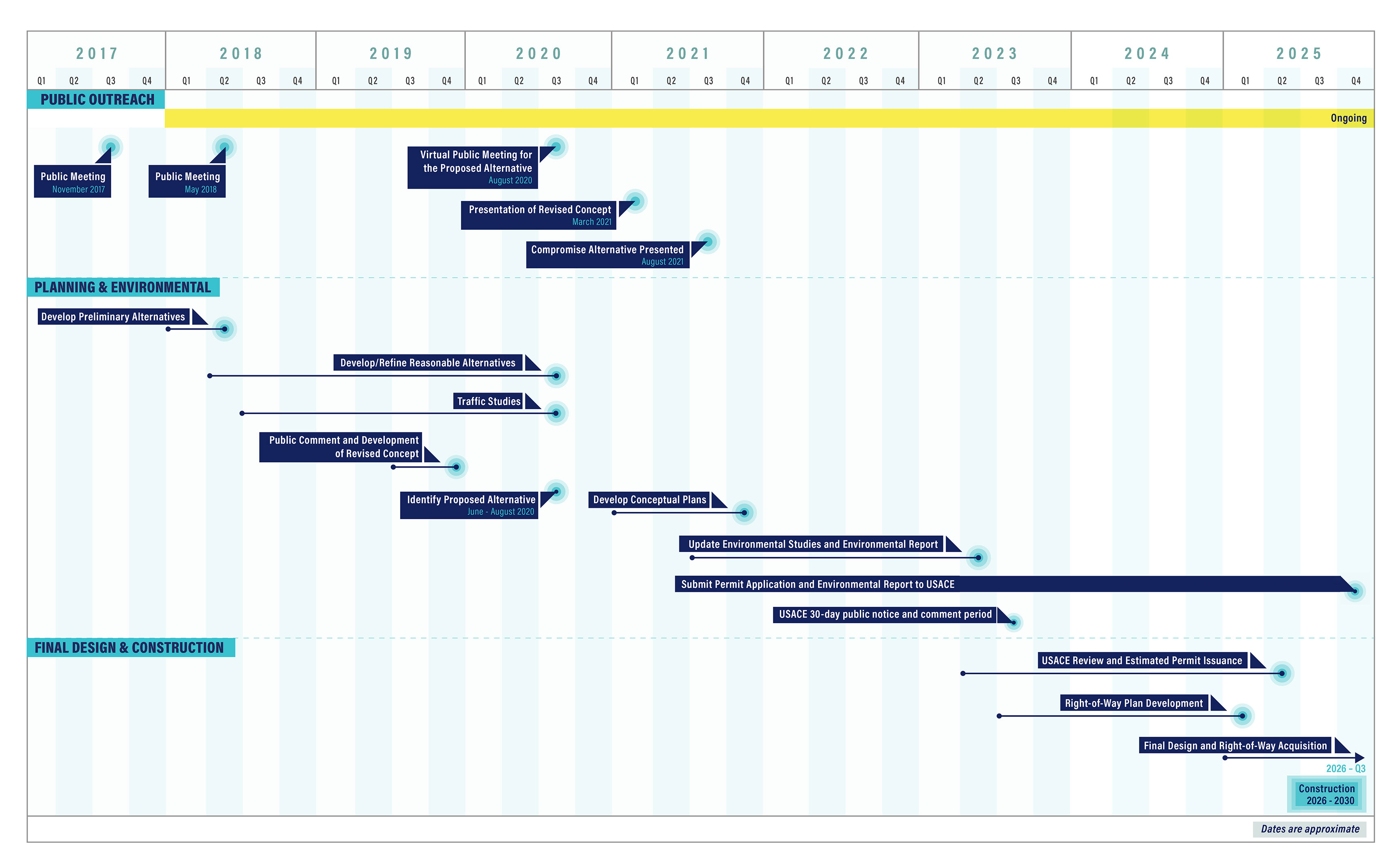
A detailed project schedule can be found below.
Dates are approximate
Public Meetings - November 2017 and May 2018
Virtual Public Meeting for the Proposed Alternative - August 2020
Presentation of Revised Concept - March 2021
Compromise Alternative Presented - August 2021
Develop Preliminary Alternatives - Spring 2018
Develop/Refine Reasonable Alternatives - Spring 2018 to Fall 2020
Traffic Studies - Spring 2018 to Fall 2020
Public Comment and Development of Revised Concept - Late 2019
Identify Proposed Alternative - June to August 2020
Develop Conceptual Plans - Throughout 2021
Update Environmental Studies and Environmental Report - Mid 2021 to Early 2023
Submit Permit Application and Environmental Report to USACE - Late 2025
USACE 30-day public notice and comment period - Fall 2023
USACE Review and Estimated Permit Issuance - Spring 2023 to Spring 2025
Right of Way Development - Fall 2023 to Early 2025
FInal Design and Right-of-Way Acquisition - Early 2025 to Fall 2026
Construction - 2026 to 2030
EMAIL THE PROJECT TEAM TO LEAVE A COMMENT OR JOIN THE MAILING LIST: HWY41SC@GMAIL.COM
LEAVE A MESSAGE FOR THE PROJECT TEAM: 843-972-4403
Charleston County Media Contact:
Chloe Field
Charleston County Government
4045 Bridge View Drive
North Charleston, SC 29405
Phone: (843) 991-1391
E-mail: CField@charlestoncounty.org

 @ChasCountyGov
 @ChasCountyGov